Other than natural and man-made factors know why North-East states facing floods every year?

As of 5 July, 179 people had died as a result of the Assam floods, and five more had reportedly drowned or been carried away the previous day. 18 of them perished in landslides.
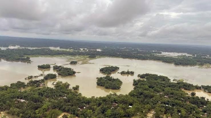
Recently the number of impacted districts decreased from 27 to 26, according to representatives of the Assam State Disaster Management Authority (ASDMA).
Meanwhile, 4 accused named Kabul Khan, Mithu Hussain Laskar, Nazir Hussain Laskar, and Ripon khan were held for the alleged sabotage act in the embankment of the Barak river in Assam’s Cachar district that is purportedly built to shield the Silchar area from floods. The Crime Investigation Department revealed that the accused damaged the embankment that led to devastating floods in Silchar on June 20. When the number of factors is indulged in the hazard that North-eastern people, the damaging the embankment is another factor added.
There are still 1,618 villages with almost 7 lakh impacted residents. 2.78 lakh of them are housed in 413 relief camps, according to an ASDMA official. 1.38 lakh homes have suffered entire or partial damage thus far.
The local authorities in Silchar, a town in southern Assam, have warned residents to exercise caution due to the Barak river’s rising water level. On Sunday, the river’s flow was just a little bit above the 19.83-meter danger level.
The eco-sensitive Kaziranga National Park and Tiger Reserve’s wildlife have also been impacted by the floods, which have caused the displacement of thousands of people.
Apart from geographical factors, a number of man-made elements have been involved in worsening this matter such as deforestation, encroachments, and embankments have all contributed to the issue. Sandbanks and islands are created by the deposition of silt from high-altitude regions.
Local residents of Arunachal Pradesh and Assam also state that the region’s flooding has gotten worse as a result of China building many sizable dams in the upper parts of the Brahmaputra, also known as the Yarlung Tsangpo there.
One of the largest river systems in Asia is the Brahmaputra basin, which rises in Tibet, flows through India and Bangladesh, and ends in the Bay of Bengal producing enormous volumes of sediment because of the stony terrain and glacial origin. The river’s speed slows when it approaches an area of relatively flat terrain (Assam), and extra silt is dumped on the river’s banks.
In addition, the river receives nourishment from more than 50 tributaries, glaciers melting in the summer, and significant monsoon rains. The effect is that the river overflows naturally during this time.
The high number of areas in the state that are prone to flooding is one of the main causes of the annual downpour. The Rashtriya Barh Ayog (RBA) estimates that 31.05 lakh hectares of the state’s total 78.523 lakh hectares are frequently subject to flooding. And both natural and man-made factors contribute to this high percentage of flood-prone areas. Current reports suggest that the situation has improved since June 20; however, a large area is still under water.
DISCLAIMER: The author is solely responsible for the views expressed in this article. The author carries the responsibility for citing and/or licensing of images utilized within the text.