The Myth of POK!

Is it Pakistan Occupied Kashmir or Jammu?
Pakistan-occupied Kashmir ( POK ) is the name given to the areas of the Princely State of Jammu and Kashmir which Pakistan intruded and occupied illegally after India gained Independence and Pakistan came into existence in 1947. It comprises the “Azad Jammu and Kashmir” (AJK) which was part of Jammu and Kashmir regions and “Gilgit-Baltistan”(GB) which was part of Kashmir and Ladakh regions of the State of Jammu and Kashmir.
The city of Sri-Lakshmi (Goddess of Wealth) or of Surya (the Sun God) as its name has variously been accounted for, stands on either bank of the Jhelum and extends to more than three miles in a curve, occupying an area of 5,139 acres on a site almost in the center of the plain of Kashmir
What is now the Province of “Jammu” was in older days, and even in later times, a congeries of hill principalities of more or less independence, according to the strength or weakness of the central authority which is known to have existed from time immemorial at Jammu. Its history has been traced back for about 5,000 years.
A succession of Hindu dynasties ruled Kashmir until 1341, when it came under Muslim rule. The Muslim period lasted nearly five centuries. From Khan Dalcha to Ahmed shah Durrani in 1747.
The early years of the 19th century witnessed the power of the Durrani declining.
The city of the great “Jambu Lochan” (for Jammu was founded by and named after that great ruler) resuscitated in 1820 by the late Maharaja Gulab Singh.
After the great victory of Attock over Afghans in 1813, and after the two failed attempts to seize Kashmir in 1814 and 1815, Maharaja Ranjit Singh got another opportunity in 1819 when a Kashmiri Pandit, “Birbal Dhar”, a revenue collector of the Valley under the Afghans, escaped first to Jammu and then to Lahore and urged the Sikh ruler to free the Kashmiris from Afghan oppression.
Gulab Singh, Dhyan Singh and Suchet Singh were the great grandsons of Surat Singh, a younger brother of Ranjit Deo, and these three brothers, distinguishing themselves at the Sikh Court of Ranjit Singh of Lahore, gradually obtained the Jammu Raj entirely for themselves.

It is said that when Maharaja Ranjit Singh put the Raj Tilak on the forehead of Gulab Singh, he did it in a very peculiar way, departing from what is considered a normal.
Maharaja Ranjit Singh put the Raj Tilak from forehead moving downwards towards nose, opposite of how a tilak is applied in the conventional way, from top of the nose moving upwards to forehead. The Sikh ruler is said to have explained that he wanted Gulab Singh’s roots to go downwards into the earth and become firm.
Sikh forces under the command of Missar Diwan Chand, properly guided by Birbal Dhar and Mian Gulab Singh, invaded the Valley in 1819. Jabbar Khan the acting Governor of Kashmir collected his troops and faced the Sikh army but he failed to stop the onslaught of the Sikh forces. After Khan’s defeat, his remaining forces returned to Srinagar, where in the darkness of night, the Afghan Governor and his forces left Kashmir by the Baramulla Muzaffarabad route heading for Kabul.
On 15 July, 1819, the victorious Sikh army entered Srinagar. The commanders of the victorious army were personally ordered by the Sikh ruler that they should take special care for the safety and the security of the inhabitants of Kashmir and also see that no harm or injury be made to any individual.
Contrary to the victorious forces of the previous rulers the Sikh forces on entering the city of Srinagar did not harm any civilian, spoil their honour nor loot the property of the wealthy shopkeepers. This was a new experience for the Kashmiris, as previously their property was looted and their honour despoiled on every occasion at the hand of the invading Afghan forces.
Gulab Singh was made Raja of Jammu in 1820, in consequence of his defeating and capturing Agha Jan, the Rajput Musalman Raja of Rajauri, who was lighting the Sikhs. Dhyan Singh obtained the principality of Punch, and Suchet Singh the Ramnagar ilaqa. With this as a nucleus, the State began to expand. Basohli, Bhadarwah, Kishtwar, Bhimber, Rajauri were conquered and absorbed one by one, and the Dogra power travelled across the heights of the north-eastern hills until it reached the Laddakh country in 1840. The Budhist Raja ruling there succumbed to the Dogra forces under Wazir Zorawar, The Mohamedan Rajas of Kharmang, Kiris, Skardu, Khapalu Shighar, etc.in Baltisan were subdued one after the other, and there remained only Kashmir with its appurtenances to be incorporated to make this extensive State complete.
Even during Maharaja Ranjit Singh’s reign, Gulab Singh had consolidated the Jammu region and started the Dogra advent into the Himalayas. After the passing of the great Punjab King, the Treaty of Amritsar in 1846 gave Maharaja Gulab Singh the title over the Kashmir Valley. It was not vacant, and the Muslim governor there put up a strong resistance to the Dogras. At the same time, there were the remarkable trans-Himalayan military expeditions by Dogra soldiers from Jammu and Himachal Pradesh, who fought pitched battles at high altitudes. The great Dogra general, Zorawar Singh, known as one of the most remarkable military commanders in world history, conquered Ladakh after stiff resistance from the local kingdom. Simultaneously, General Baj Singh, Mehta Basti Ram and other Dogra generals conquered Gilgit-Baltisan. In the process, the Dogras suffered heavy casualties, but succeeded in establishing the Dogra empire of J&K, which emerged as the largest princely state in British India. Gulab Singh’s successor, Maharaja Ranbir Singh added Hunza and Nagar as tributaries to what was the Dogra empire. Thus, the Kashmir region in its contemporary form dates from 1846, when, by the treaties of Lahore and Amritsar at the conclusion of the First Sikh War, Raja Gulab Singh the Dogra ruler of Jammu, was created maharaja (ruling prince).

According to the Census of 1911 & 1921, the State is classed under the major head, “Western Himalayas and Sub-Himalaya”, and within this head the internal divisions determined are:
This is the partly plain and partly broken kandi country skirting the great mountain ranges of the Himalayan series, and consists of tehsiis Kathua and Jasmirgarh of Jasrota district, the entire district of Jammu, and tehsiis Bhimber and Mirpur of the Mirpur district. This practically includes all the Dugar and Chibhal ilaqas.
Consisting of the country of low-lying hills this side the Pir Panjal ranges and all the southern side of that range of mountains itself. It is to these low mountains that the name of Siwalik (sawa lakh) is given because of their number. The Chinab river, with its numerous feeder streams, flows through this country until it emerges into the plains at Akhnur. Basohli tehsil of Jasrota, Kotli of Mirpur and the entire districts of Riasi and Udhampur, as well as the jagirs of Punch and Bhadarwah are comprised in this division.
Comprises the flat and wide upper section extending from south-east to north-west, called Kashmir proper, together with its side-valleys, and the hilly and sloping portion of it named the Wizarat-i-Pahar (Muzaffarabad*),including the Krishna Ganga valley. This part is enclosed by the Panjal on the one side and the great Central Range separating the Indus valley on the other. It includes all the seven tehsiis of the Kashmir Valley proper and the three of the district of Muzaffarabad.
These form the central portion of the valley of the great Indus river which, taking its origin in the Mansarovar Lake in Tibet proper, traverses the whole Frontier Province of this State, running from south-east to north-west. It is enclosed by the central range of the Himalayas on the south and the Karakorum mountains on the north. This part of the country is highly mountainous and is meager both in cultivation and population. The physical characteristics of the many portions of this country vary according as it slopes down from east to west, and we have the almost rain less and therefore dry and barren tract of Laddakh on the one extreme, and the semi-Tibetan country of Baltistan and Gilgit on the other, where the lower hillsides and valleys are verdant with orchards and corn fields. This division comprises the Laddakh and Gilgit districts and the Frontier dependencies.
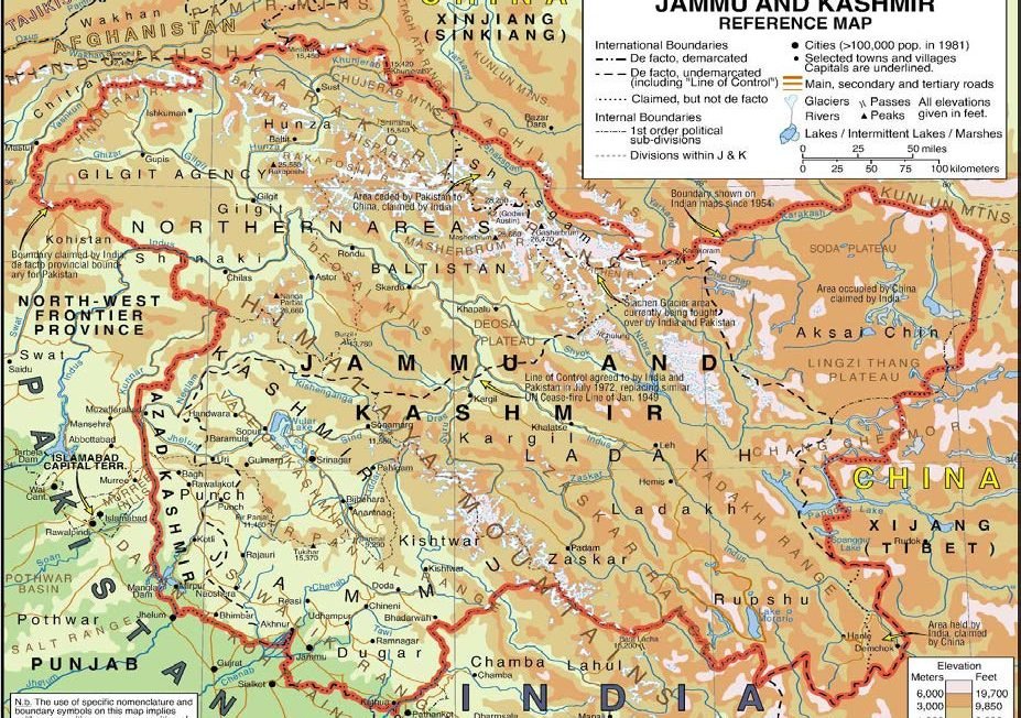
Pakistan occupied Jammu & Kashmir (PoK) is constitutionally an integral part of the Indian Union and remains under Pakistani occupation since 1947, when Pakistan’s Army engineered a tribal invasion and took control of more than 114,500 square kilometers of J&K. Pakistan declared its occupied part as ‘Azad’ or free and conferred to J&K Muslim Conference, a pro-Pakistani local political party, to constitute its first titular government. Subsequent to occupation, Pakistan embarked on the agenda of usurping J&K. First to be annexed was Gilgit-Baltistan, which went under the direct control of Pakistan in 1949, as the leaders of AJK Muslim Conference were forced to hand over these regions of J&K through the ‘Karachi Agreement’.
Likewise, Shinaki Kohistan and Chitral, which constituted parts of Jammu & Kashmir before its partition in 1947, were also annexed and merged into the NWFP of Pakistan in 1955 and 1970 respectively. Later, when Pakistan and China agreed to demarcate ‘international border’ in 1963, Pakistan provisionally ceded 19,313 sq. kilometers of trans-Karakoram track of J&K including the segment of Baltistan known as ‘Shaksgam’ and part of Gilgit called ‘Raskam’ to China. Currently, the parts of Kashmir province under PoK is divided into three districts of Muzaffarabad, Bagh and Neelum, while the parts of Jammu province under PoK is divided into five districts namely Poonch/ Rawalakot, Sudhnati/Pallandari, Bhimber, Kotli and Mirpur.
Area under illegal occupation of Pakistan:
Kashmir (Muzaffarabad Division) comprises of 3 districts: Bagh, Muzaffarabad and Neelum
Jammu (Mirpur Division) comprising of 5 districts: Bhimber, Kotli, Mirpur, Sudhnati/Pallandari and Rawalakot/Poonch
Frontier Ares of Gilgit Baltistan: 72,496 sq. kilometer
Districts: seven
Baltistan Region (part of Ladakh) is divided into
Ganche and Skardu districts
Gilgit Region is divided into Astore, Diamer, Ghizer,
Hunza-Nagar and Gilgit districts
Area ceded to China by Pakistan: 19,313 sq. kilometer
Area of Chitral: 14,850 sq. kilometer
Area of Shinaki-Kohistan: 5,398 sq. kilometer.
The Tract is one of the most inhospitable areas of the world, with some of the highest mountains including Broad Peak, Gasherbrum and Masherbrum, and is adjacent to the highest battlefield in the world at Siachen Glacier.
This leaves the question, whether the territories occupied by Pakistan, lies under Kashmir province or Jammu? Well the historical and geographical report says the major parts were under Jammu province, then why we call it “Pakistan occupied Kashmir”
Keeping in mind the geographical and cultural settlements of the undivided J&K, the abrogation of Article 370 and 35 A is seems to be a Masterstroke by present government; it leads to the resuscitation of the 2 Union Territories and a State. Laddakh (Along with Gilgit, Baltistan and Hunza), and Jammu (Along with Mirpur, Kotli, Neelum)and Kahmir (Along with Muzzafrabad).
Aspirations of the Dogras of Mirpur and Muzzafrabad were crushed and the present identity crisis of the region is ruining the great glory and lineage of the Brave Dogras. The unique multi-regional, multi-linguistic, multi-religious and multi-cultural state of J&K was thus the handiwork of the Dogras, who have not received adequate attention or credit for this from historians.
DISCLAIMER: The author is solely responsible for the views expressed in this article. The author carries the responsibility for citing and/or licensing of images utilized within the text.